
 As
with all flying adventures, a constant concern is what the weather will
really be like over the next part of the route. It had been our intention to
take a fairly direct heading passing Boise, Idaho to Kalispell, Montana
where we had a rendezvous with an old friend. Boise brought good memories
back to us from a previous visit a year ago in 2002 on the way to Alaska so
we considered it worth a stop-over. However, a persistent depression with an
active weather front was busy extinguishing the numerous wildfires around
Boise. Thus, we decided to divert along the coast to Portland and then east
across the Cascades to our destination. This meant a route of 860nm instead
of the direct 720nm.
As
with all flying adventures, a constant concern is what the weather will
really be like over the next part of the route. It had been our intention to
take a fairly direct heading passing Boise, Idaho to Kalispell, Montana
where we had a rendezvous with an old friend. Boise brought good memories
back to us from a previous visit a year ago in 2002 on the way to Alaska so
we considered it worth a stop-over. However, a persistent depression with an
active weather front was busy extinguishing the numerous wildfires around
Boise. Thus, we decided to divert along the coast to Portland and then east
across the Cascades to our destination. This meant a route of 860nm instead
of the direct 720nm.
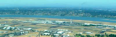
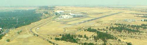
 July
26 Today with Joan at the controls we headed north to Portland,
Oregon, a comfortable 460 nm ( 850 km) trip. After departing Napa (KAPC) we flew up the Valley, north passing Redding,
general direction toward Eugene, Oregon. The flight was smooth until we came
to the Trinity Mountains or Alps where the clouds were low over part of the
summit and the wind jerked us
around like we were on one of those body slamming amusement rides. Once out,
the sky cleared and after passing Eugene we started to descend closing in on our destination of Portland
(KPDX). The last time we had seen the city from the air was on the way to
Alaska from an altitude of 14'000 ft. After
calling Approach, the instructions were to fly directly to city center and
then direction tower. Shortly before seeing the faces of the controllers we
cranked a hard right onto downwind, slotted between approaching airliners
and hoped that the wake turbulence would subside enough to land right side
up. Once again parked, unpacked and tied down. The comfortable Executive FBO was just the kind of
place one wants to walk into after an early morning flight that somewhat
rattled our brains. Of course quality and service has it's price reflecting
in the fuel price.
July
26 Today with Joan at the controls we headed north to Portland,
Oregon, a comfortable 460 nm ( 850 km) trip. After departing Napa (KAPC) we flew up the Valley, north passing Redding,
general direction toward Eugene, Oregon. The flight was smooth until we came
to the Trinity Mountains or Alps where the clouds were low over part of the
summit and the wind jerked us
around like we were on one of those body slamming amusement rides. Once out,
the sky cleared and after passing Eugene we started to descend closing in on our destination of Portland
(KPDX). The last time we had seen the city from the air was on the way to
Alaska from an altitude of 14'000 ft. After
calling Approach, the instructions were to fly directly to city center and
then direction tower. Shortly before seeing the faces of the controllers we
cranked a hard right onto downwind, slotted between approaching airliners
and hoped that the wake turbulence would subside enough to land right side
up. Once again parked, unpacked and tied down. The comfortable Executive FBO was just the kind of
place one wants to walk into after an early morning flight that somewhat
rattled our brains. Of course quality and service has it's price reflecting
in the fuel price.
 After
checking into a hotel, probably built in the city's founding days we canvassed the City for a few hours and had a
coffee. Our impression was that there must be a lot more to Portland than met our eyes. What we had
read and heard did not match up. We decided to come back and give it another
try. Maybe we were just tired from the testing days in Napa.
After
checking into a hotel, probably built in the city's founding days we canvassed the City for a few hours and had a
coffee. Our impression was that there must be a lot more to Portland than met our eyes. What we had
read and heard did not match up. We decided to come back and give it another
try. Maybe we were just tired from the testing days in Napa.
 Strangely enough, we
were missing the chart into Montana and the FBO was also out of the one we
needed. A helpful person called a close by airport and arranged for us to
pick up the missing chart (and give us a chance to compare fuel prices). Those airport people in the Portland area were
great in everyway and again, just the kind of people you want to deal with
on a long journey.
Strangely enough, we
were missing the chart into Montana and the FBO was also out of the one we
needed. A helpful person called a close by airport and arranged for us to
pick up the missing chart (and give us a chance to compare fuel prices). Those airport people in the Portland area were
great in everyway and again, just the kind of people you want to deal with
on a long journey.
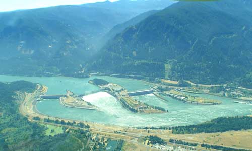 July
27 We were off to Kalispell, Montana (KFCA) with Ueli pushing the
throttle and Joan capturing the beautiful scenery. A flight of 400 nm ( 740
km) across relatively barren land lay ahead. Portland Departure requested us to
stay low and north of the
Columbia River up to the gorge
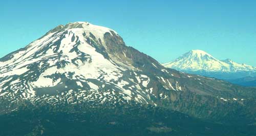
cutting across the Cascades. We did not mind as this way we could see the beauty of the
area close up while in the background many snow capped volcanic mountains
beckoned us to climb. It
was spectacular and we thought again about Portland. Due to our short stay
we must have missed the essence of the City. We would definitely to go back
and spend a bit more time here.
July
27 We were off to Kalispell, Montana (KFCA) with Ueli pushing the
throttle and Joan capturing the beautiful scenery. A flight of 400 nm ( 740
km) across relatively barren land lay ahead. Portland Departure requested us to
stay low and north of the
Columbia River up to the gorge
cutting across the Cascades. We did not mind as this way we could see the beauty of the
area close up while in the background many snow capped volcanic mountains
beckoned us to climb. It
was spectacular and we thought again about Portland. Due to our short stay
we must have missed the essence of the City. We would definitely to go back
and spend a bit more time here.
 Flying
east in direction of Spokane, an interesting observation was the significance of Columbia River as a
lifeline flowing south from Canada through the relatively dry land east of
the Cascades, giving opportunities to many agricultural centers and power
generating facilities. This is the route where Lewis and Clark had
discovered the land in fall of 1805 on the way to the pacific.
Flying
east in direction of Spokane, an interesting observation was the significance of Columbia River as a
lifeline flowing south from Canada through the relatively dry land east of
the Cascades, giving opportunities to many agricultural centers and power
generating facilities. This is the route where Lewis and Clark had
discovered the land in fall of 1805 on the way to the pacific.
The areas between the green valleys are used as sparse grazing grounds the vast wonderland of prairie. Occasionally military training facilities and ammunition depots are trying to hide from curious eyes.
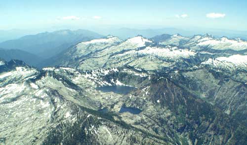
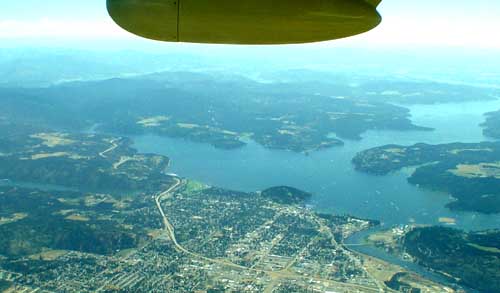 Cruising
at 11,000ft over Coeur d�Alene we were tempted to stop and check out the
breathtaking areas between green hills and deep blue lakes. The sight of
floatplanes on the calm lake stirred memories of our love to fly floatplanes.
A mental note was made to come back to this remote corner of the USA. However, a little challenge lay
ahead. A new TFR (Flight Restriction Area) due to forest fires along our flight route had to be
avoided and an IFR approach into Kalispell could become necessary because of
heavy smoke. The strong wind higher up created the well known jet stream
boundary turbulence which cautioned us on descent toward the mountain peaks
to respect their ever present unpleasant bumps. Without further surprises we landed
in VFR at
Kalispell directed by a very busy controller slotting us in among a beehive
of water bombers, etc. The wind had cleared the smoke that fills the valley
during the night to offer a sunny reception.
Cruising
at 11,000ft over Coeur d�Alene we were tempted to stop and check out the
breathtaking areas between green hills and deep blue lakes. The sight of
floatplanes on the calm lake stirred memories of our love to fly floatplanes.
A mental note was made to come back to this remote corner of the USA. However, a little challenge lay
ahead. A new TFR (Flight Restriction Area) due to forest fires along our flight route had to be
avoided and an IFR approach into Kalispell could become necessary because of
heavy smoke. The strong wind higher up created the well known jet stream
boundary turbulence which cautioned us on descent toward the mountain peaks
to respect their ever present unpleasant bumps. Without further surprises we landed
in VFR at
Kalispell directed by a very busy controller slotting us in among a beehive
of water bombers, etc. The wind had cleared the smoke that fills the valley
during the night to offer a sunny reception.
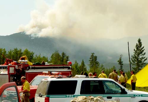
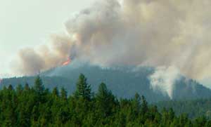 The fires in Glacier
National Forest were horrendous. It was THE topic everywhere as it affected
the tourist depending economy. In the mornings, the valleys were blanketed
with smoke. Only a brief respite in the afternoons allowed one to see the
beautiful but hazy mountains of this glorious park. The day after our
arrival the winds
changed in late morning, making visibility better.
The fires in Glacier
National Forest were horrendous. It was THE topic everywhere as it affected
the tourist depending economy. In the mornings, the valleys were blanketed
with smoke. Only a brief respite in the afternoons allowed one to see the
beautiful but hazy mountains of this glorious park. The day after our
arrival the winds
changed in late morning, making visibility better.
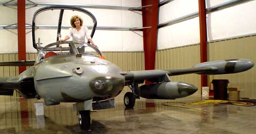
We explored the area by car, but because of the overwhelming fires, no one could venture into the Park. It was heartbreaking to witness the magnitude of devastation. We felt so grateful to be spared of what so many were experiencing. Ueli videoed and Joan took pictures to document the disaster. The firefighters were exhausted and in many areas there was simply nothing anyone could do to contain the fires at that given time.
 We
took advantage
We
took advantage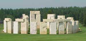 of the window and flew out to a private airstrip visiting old friends. We were treated
to lunch and caught up on the last 15 years of our life. Then, as the climax
we were shown and could check out a wonderful collection of historical
airplanes, all in flying condition. Next to the runway stood an exact replica of Stonehenge
(where other airports have an ordinary VOR transmitter). Extraordinary was the only word to describe that experience.
of the window and flew out to a private airstrip visiting old friends. We were treated
to lunch and caught up on the last 15 years of our life. Then, as the climax
we were shown and could check out a wonderful collection of historical
airplanes, all in flying condition. Next to the runway stood an exact replica of Stonehenge
(where other airports have an ordinary VOR transmitter). Extraordinary was the only word to describe that experience.
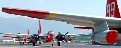
On the flight back to Kalispell the devastating fires caused heavy air traffic from the helicopters and water bombers buzzing around like at a bee hive. It was time to get out of the way, tie the plane down leave the airspace for the fatigued fighters.
Montana is one of the most beautiful States as seen by our eyes and has a wealth of things to explore and experience. It is a place to have a wonderful quality of life and much quiet time. Over the years we have returned time and time again. Sometimes we think the thought of those heavenly huckleberry milkshakes have a play in our decision to return.
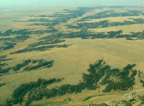
July 30 We crossed over the Rockies with it's smoke filled valeys and headed in the direction SE to Billings, Montana 300 nm ( 550 km) away. The wind was strong on our tail but calmed down once over the plains. The terrain is dry and at first glance looks barren and desolate. However, when studying it a bit closer, there is much more than first meets the eye. The old river beds, rock formations and coloring makes one think how it must have looked ages ago.
 Approaching
the airfield of Billings International (KBIL) was uneventful until turning
base to final for runway 28 over the city still at 2000 ft above ground but
then to see that you are only 1000 ft over the runway. The airport sets on a
plateau overlooking the City to the south. There is one corner of the
pattern that feels like it�s missing until well established on final. Who
knows, maybe we flew it wrong! It was OK for the Tower controller but it
just felt strange.
Approaching
the airfield of Billings International (KBIL) was uneventful until turning
base to final for runway 28 over the city still at 2000 ft above ground but
then to see that you are only 1000 ft over the runway. The airport sets on a
plateau overlooking the City to the south. There is one corner of the
pattern that feels like it�s missing until well established on final. Who
knows, maybe we flew it wrong! It was OK for the Tower controller but it
just felt strange.
 In Billings, the
people are friendly and helpful. We
were there to check out avionics equipment to update the panel in N85S. The
possibilities are endless, interesting and expensive. We decided to go to
the local Barnes & Noble, check out several books and have a Starbucks
coffee to hash over all the information we received. We promptly fell asleep
in those big overstuffed chairs and came to at some point. It was time to go
home.
In Billings, the
people are friendly and helpful. We
were there to check out avionics equipment to update the panel in N85S. The
possibilities are endless, interesting and expensive. We decided to go to
the local Barnes & Noble, check out several books and have a Starbucks
coffee to hash over all the information we received. We promptly fell asleep
in those big overstuffed chairs and came to at some point. It was time to go
home.
July 31 On the last leg of our journey, 420 nm (780 km), back to Boulder there were the usual afternoon CB�s forecasted and they can be rather nasty along the Front Range of the Rocky Mountains. A frontal system had established itself in the mountains forcing us to keep east. Over Cheyenne we bucked the usual winds, coming out of the direction of Laramie, which never seem to cease. We wasted no time getting home and the controller gave us a direct vector to Boulder. We looked forward to sleeping in our own bed again after this grand tour of the western United States it was splendid! It was a 2710 nm (5020 km) round trip.
Return to our main web page of WeFly4Fun.com
Response and suggestions are appreciated to [email protected]
This page was last serviced on 26. February 2004